Address
Commissioner Secretariat, Main RCD Road Khuzdar, Balochistan
info@commissionerkalat.gob.pk
Phone No
+92 848 000 0000
Fax: +92 0848 111 1111
Office Hours
Monday-Friday: 9AM to 5PM
Sat-Sun- OFF
| District Headquarter | Khuzdar |
|---|---|
| Date of Notification | 1st March 1974 |
| Population (2023) | 997,214 |
| Area | 43,261 sq.km |
| Religion | Muslim 99.14% Hindu 0.41% Christians 0.3 % |
| Languages | Brahvi 78.93% Balochi 18.74% Sindhi 1.22 % |
| Tehsils (04) | Khuzdar, Zehri, Naal, Wadh |
| Union Councils | 53 |


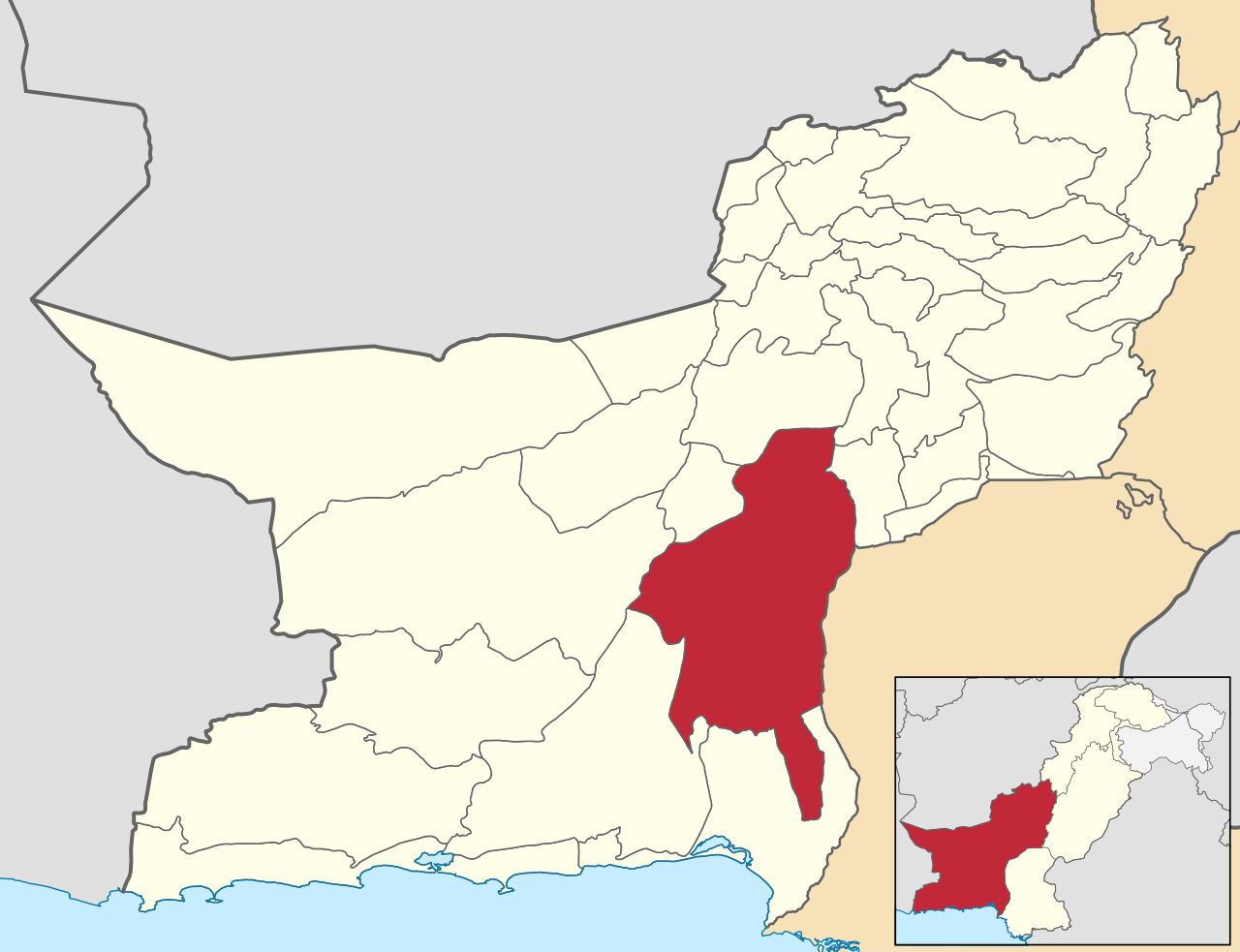
Khuzdar is a significant district in Pakistan’s Balochistan province, serving as its administrative capital of the largest division of Pakistan, Kalat Division. It functions as both the district and divisional headquarters. The district borders several others within Balochistan, including Awaran, Bolan, Kharan, Hub, Lasbela, Kalat, and Jhal Magsi, as well as the Sindh districts of Larkana and Naushahro Feroze.
As of the 2017 census, Khuzdar had a population of just over 800,000 people. The district is home to various influential tribes, such as the Bizenjo, Hasni, Zehri, Mengal, Nausherwani, Zarakzai, Ahmadzai, and Kurd. Covering an area of 35,380 square kilometers, Khuzdar is the largest Brahui-speaking district in Balochistan. While agriculture is limited, with small-scale cultivation of rice, wheat, cotton, mangoes, and dates, the district is rich in natural resources like Barite, Chromite, and Onyx.
Historians have linked Khuzdar, to several historical names, including KOHYAR, TOORAN, Qazdar, and Jhalawan.
Khuzdar District is situated in the central region of Balochistan, Pakistan. Historically, it was part of Jhalawan, a highland division of the Kalat State. Khuzdar served as the headquarters of Jhalawan until 1955, when the One Unit Policy abolished all provincial boundaries in West Pakistan.
Ancient History
The ancient history of Khuzdar is largely obscure, with limited corroborated details prior to the arrival of the Arabs in the 7th century AD. During the Rai Dynasty of Sindh, which ruled over an extensive region including parts of present-day Balochistan, this area was known as Turan with its capital at Khuzdar.
Alexander the Great and Early References
British geographer Sir T. Holdich suggested that part of Alexander the Great’s army passed through the Mula Pass and traversed Choarene, which has been identified as Khuzdar. The region is still referred to as Kohiar by some locals, an ancient name for the area. The next significant mention of Khuzdar came with the Rai Dynasty of Sindh, which extended its influence as far as Kandahar (in modern Afghanistan), Seistan (Persia), and the Suleiman and Kaikanan hills of Balochistan. Kaikanan, located near Kalat, is associated with present-day Nal in Khuzdar.
Arab Conquest and Rule
In 664 AD, during the caliphate of Muawiya, the Arabs conquered Khuzdar from the Rai Dynasty. The Arab army, led by Al-Manzar, established Khuzdar as their capital. The region’s strategic location and moderate climate made it favorable for settlement and development. An Arab historian, Al Biladhuri, described Khuzdar as a beautiful and distinguished place.
Medieval Period
In 997 AD, Sultan Nasir-ud-Din Sebuktigin, the founder of the Ghaznavid Empire, invaded and briefly conquered Khuzdar. However, Khuzdar was restored to its previous rulers through a treaty requiring annual tribute. Despite attempts to resist, the rulers paid the tribute and gifts to maintain their dominion. In 1047-48, Khuzdar was again conquered by the Ghaznavids under Mahmood’s grandson, Maudud, after a rebellion.
Following the decline of the Ghaznavids, Khuzdar came under the control of the Ghorids and then Nasir-ud-din Kabacha, the Muslim Turk governor of Multan. By 1225 AD, Khuzdar was under the rule of Shamsuddin Altamash, who initially had Malik Bahram Shah as the governor before the area was taken over by the Mongols. Malik Bahram Shah’s tomb is located in Washuk.
Soomra and Samma Dynasties
During the 14th century, the Soomra and Samma dynasties controlled Sindh, including Khuzdar at their peak. The Jat tribes, who previously held power, were overthrown by the rising Brahvi (or Brahui) tribe, which eventually came to dominate the region under Mir Bijar Khan, a contemporary of Mir Chakar Khan Rind.
Mughal and Kalat Rule
Khuzdar was integrated into the Mughal Empire and governed by the Zehri tribe. By the mid-15th century, the Brahvis had consolidated power, and Khuzdar became part of the Kalat Princely State. Under Mughal rule, it served as the seat of the Kalat Government and the residence of the Khan’s representative.
British Period
Henry Pottinger visited Khuzdar in 1810 and described it as a valley surrounded by mountains and a low mud wall. He noted that Hindus from Multan and Shikarpur had gained significant trust and responsibility, including managing the town gate keys.
In 1869, there was a rebellion in Jhalawan/Khuzdar led by Noor ud-Din Mengal, which was suppressed. Another uprising from 1893 to 1895, led by Gauhar Khan of the Zehri tribe, was also quelled by the Kalat State troops in the battle of Garmap.
In 1903, the British Government established a political agent in Khuzdar to manage administrative affairs, a system that continued until the Partition of India.
Modern Administration
Khuzdar was designated as a separate district on March 1, 1974, after previously being part of Kalat district.
Archaeological Significance
Khuzdar District features many archaeological remains, including the gabarbands or embankments of ancient fire worshippers. Notable sites include Ahmad Band and one near Pir Munaghara in Sarona. Other significant archaeological finds include a vaulted burial chamber at Pandran, tombs, earthen vessels, stones with Kufic inscriptions, and the Palace Mound (Meri Bhar), believed to be the seat of the last Mongol governor, Malik Chap. Shahi Bagh remains a testament to the city’s historical significance.
Khuzdar is situated at the tip of a narrow valley, with an elevation of 1,237 meters (4,058 feet). The district extends about 318 kilometers from north to south and 175 kilometers from east to west, sloping gradually southward.
Khuzdar district is predominantly mountainous, characterized by numerous ridges and valleys of varying widths. The terrain consists of folded sandstone and shale. Key mountain ranges include:
Significant mountains in the district’s center include Dobanzil (2,239 meters), Hushtir (2,212.8 meters), Shashan (2,290 meters), and Dra Khel (2,469.5 meters). The general elevation of the district ranges from 1,800 to 3,000 meters above sea level, while Khuzdar city is at 1,237 meters.
Important valleys in the district are Surab, Gidar, Baghwana, Zehri, Khuzdar, Firozabad, Wadh, Nal, Saruna, Jau, and the Mashkai River valley.
Other notable seasonal rivers and streams include Kohan, Saruna, Labil, Dara, Hator, Mosina, Kolachi, and Bini. The mountainous terrain generates numerous seasonal streams during the rainy season, such as Shandi Jhal, Khisun Band Jhal, Sang Nal Jhal, Kappak Jhal, Charri Jhal, Parpuki Jhal, and Chil Jhal.
There are no freshwater lakes or ponds in the district.
Khuzdar district falls within the Dry Sub-Tropical and Temperate Semi-Evergreen Scrub Forest zone. Natural vegetation is predominantly rangelands, which are crucial for ecological stability and economic development.
The district’s forest areas include:
Khuzdar district features various soil types:
Khuzdar experiences warm summers and cold winters, with significant temperature fluctuations between day and night. June is the hottest month with temperatures averaging 38°C (maximum) and 25°C (minimum). January is the coldest, with temperatures averaging 17°C (maximum) and 3°C (minimum). Winds in winter blow from the north (known as goorich), while in summer, they come from the south and southeast (known as numbi). The district receives an average annual rainfall of about 244 mm, primarily during winter.
Khuzdar district falls under Seismic Zone 2B, indicating a risk of minor to moderate earthquake damage.
Khuzdar district exhibits diverse vegetation across various zones:
Uphill Steep Slopes:
Foothills, Piedmont Plains, and Stream Beds:
Ground cover plants include Stipa himalacia, Dichanthium annulatum, Chrysopogon aucheri, and various Cymbopogon species.
Mammals:
Birds (Avifauna):
Reptiles:
Khuzdar district has several designated protected areas:
These sanctuaries provide protection to species such as the black bear, urial, ibex, chinkara deer, and migratory birds.
Additionally, there are two private game reserves:
Khuzdar district is part of the barani (rain-fed) region, meaning agriculture relies predominantly on rainfall. The district supports a diverse range of crops, fruits, and vegetables.
The key crops cultivated in Khuzdar include:
The district produces a variety of fruits, including:
Khuzdar also supports the cultivation of various vegetables, such as:
These crops and produce are essential to the local economy and diet, showcasing the agricultural diversity of Khuzdar district.
Khuzdar district has a rich tradition of handicraft cottage industries, which produce a variety of items using local materials and traditional techniques.
One prominent source of handicraft materials is the mazri plant, whose leaves and other parts are used to make:
These products are integral to local craftsmanship and serve various domestic purposes.
Local artisans, particularly the Channal (a class of professional weavers), create various woven items, including:
These woven articles are valued for their quality and traditional designs.
Balochi embroidery is a notable craft in Khuzdar, with embroidered products including:
This intricate embroidery is highly regarded and is sold in major markets like Karachi and Quetta. Despite the high quality of these products, inadequate marketing means that middlemen often take a significant portion of the profits.
There is potential for the development of small industries in Khuzdar, particularly in:
These industries could provide additional economic opportunities and help retain more profits within the local community.
Commissioner Secretariat, Main RCD Road Khuzdar, Balochistan
info@commissionerkalat.gob.pk
+92 848 000 0000
Fax: +92 0848 111 1111
Monday-Friday: 9AM to 5PM
Sat-Sun- OFF
© All Rights Reserved. Commissioner Kalat Division

Typically replies within an hour