Ancient and Medieval Periods
Early Conquests and Settlements:
- Alexander the Great: In 325 BC, Alexander’s retreat from India took him through Lasbela and Makran. His empire later passed to Seleucus Nicator, who established the Seleucid Empire, and subsequently to the Graeco-Bactrian kings, who were overthrown by the Sakas around 130 BC.
- Buddhism and Sassanian Empire: During the Saka period, Buddhism flourished in the region. The Sassanians expanded eastward, but the areas of Chagai, Kharan, and northwestern Kalat were only conquered under Nausherwan (529-577 AD).
Sewas Dynasty and Arab Conquest:
- Sewas Dynasty: The Sewas, a Hindu dynasty, ruled until the 7th century Arab invasion. Local traditions link them to the Rai Dynasty of Sindh.
- Arab Rule: Arabs captured Khuzdar in 664 AD and later under Muhammad Bin Qasim in 711, establishing their influence in the region.
Ghaznavids to Mughals:
- Ghaznavids and Ghorids: After the Arab period, the Ghaznavids and then the Ghorids controlled the area. The Mongols, led by Genghis Khan in 1223, raided the region, briefly bringing parts of Balochistan under their rule.
- Soomra and Samma Dynasties: These dynasties in Sindh extended their influence into Jhalawan.
- Brahui Rise: By the 14th century, the Brahui tribes began to assert control, with their principality expanding to Khuzdar.
Kalat Princely State and British Rule
Formation and Expansion:
- Kalat State Formation: In 1666, Mir Ahmad Khan Qambrani established the Kalat Khanate, consolidating Baloch and Brahui territories. It remained a princely state until 1955.
- Mir Nasir Khan I: Reigned from 1750-1794, during which the Brahui power reached its zenith. His rule saw the expansion of Kalat’s influence over neighboring regions.
British Influence and Political Changes:
- British Interaction: The British began interacting with Kalat during the First Afghan War in 1839. They occupied Kalat briefly but withdrew, and by 1876, established stronger political control through treaties with Khan Khudadad Khan.
- British Acquisition: Parts of Kalat State were leased or acquired by the British over time, including Quetta and Bolan Pass in 1883 and 1899, respectively.
- Kalat’s Accession to Pakistan: In 1948, Kalat State acceded to Pakistan. It became part of the Balochistan States Union and was merged into West Pakistan in 1955, with Kalat becoming a separate district.
Modern Era
District Organization:
- Initial Division: On February 3, 1954, Kalat was officially notified as a district. Initially, it included Khuzdar, Mastung, Bolan, Jhall Magsi, and Dera Murad Jamali, which were later separated into individual districts.
- Current Structure: Kalat district now comprises two sub-divisions: Kalat and Manguchar. It includes four tehsils: Kalat, Mangochar, Johan, and Gazgz.
Historical Significance:
- Cultural Heritage: Kalat’s rich history reflects a blend of various influences, from ancient conquerors to local dynasties, making it a significant cultural and historical region in Balochistan.
This comprehensive history outlines Kalat’s evolution from ancient settlements through its role as a princely state and its integration into modern Pakistan.
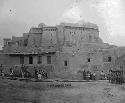
- Kalat Miri (Kalat Fort):
- Location: Kalat.
- Description: Although destroyed in the 1935 earthquake, the ruins of this historic fort still stand, offering insights into the region’s architectural and military history.
- Guru Nanak Sahib Shrine (Guru Nanak Darbar):
- Location: Old city of Kalat.
- Description: An important religious site for the Sikh community, also known as Nanak Mandir. It commemorates Guru Nanak Sahib, the founder of Sikhism.
- Shrine of Ghous Pak:
- Location: On top of a cone-shaped hill.
- Description: A revered religious site, the shrine is situated on a prominent hill, providing panoramic views of the surrounding area.
- Harboi Hills:
- Location: Kalat District.
- Description: Known for their picturesque juniper forests, these hills offer scenic beauty and a tranquil environment.
- Nindo Damb, Omach Valley, Wadh:
- Location: Wadh, Kalat.
- Description: An archaeological site protected under Pakistani laws. It has been identified as an area occupied by the Harappan Civilization, revealing significant historical insights.
- Miri/Merry Court:
- Location: Kalat.
- Description: The former palace of the Khan of Kalat, reflecting the region’s royal heritage and architecture.
- Sra Dhaka:
- Location: A village in Kalat.
- Description: Known for its beautiful flowers, this village is a charming spot for nature enthusiasts and those seeking a serene environment.
- Shah-e-Mardan Hills:
- Location: Kalat District.
- Description: These hills are renowned for their natural beauty and offer opportunities for hiking and enjoying the scenic landscape.
These sites reflect the rich cultural and historical heritage of Kalat District, making it a compelling destination for both history buffs and nature lovers.
Geographical Overview:
- Kalat District is part of the Upper Highlands of Balochistan.
- The district is characterized by a mountainous terrain with parallel mountain ranges running northwest.
- The elevation ranges from 1,525 to 1,982 meters above sea level in some valleys, making it one of the higher altitude regions in Balochistan.
Key Features:
- Surab Tehsil: Located at an elevation of 2,133 meters above sea level.
- Kalat City: Positioned at a lower elevation of 610 meters above sea level.
- Mountain Ranges:
- Koh-i-Maran: Notable for its height and prominence in the region.
- Harboi Mountain Range: Reaches an elevation of 2,743 meters, one of the highest points in the district.
Valleys:
- Mungochar Valley: Situated in the western part of the district.
- Chhappar Valley: Another significant valley contributing to the district’s topographical diversity.
Rivers, Streams, and Lakes
Rivers:
- Moro River: Flows through Johan and continues into Mastung District.
- Sheerinab River: Originates in the Harboi Hills and eventually joins the Shorarud River, which flows into the Pishin Lora.
Streams:
- Mushmunki Jhal: A seasonal stream originating from the mountains.
- Tharki Rud: Another seasonal stream.
- Rashkan Rud: A stream that flows intermittently.
- Rej River: Part of the seasonal stream network.
Lakes:
- No lakes: Kalat District does not have any natural lakes.
Forests
Forest Coverage:
- Total forested area: 68,071 hectares.
- Forest types include Dry Temperate Scrub (Steppe) Forests similar to the juniper forests of Ziarat.
Types of Forests:
- Natural Forests:
- Dasht-e-Baddo: 809 hectares.
- Mangochar: 4,047 hectares.
- Harboi: 22,351 hectares.
- Muhammad Shahi: 10,161 hectares.
- Shiekhani: 14,569 hectares.
- Narwari: 12,432 hectares.
- Total Natural Forest Area: 64,369 hectares.
- Artificial Plantations: Includes various conifers and other trees.
Major Tree Species:
- Greek Juniper (Juniperus excelsa polycarpos): Dominant in favorable sites.
- Wild Ash (Fraxinus xanthoxyloides): Found in various parts of the district.
- Shina/Khanjak (Pistacia khinjuk): Common in the area.
Shrubs and Ground Cover:
Shrubs:
- Wild Almond (Prunus spp.)
- Honeysuckle (Lonicera quinquelocularis, Lonicera hypoleuca)
- Himalayan Abelia (Abelia triflora)
- Barberry (Berberis vulgaris)
- Wild Rose (Rosa beggeriana)
- Tharkha (Artemisia maritime)
- Hawthorn (Crataegus spp.)
- Kala Zira (Carum bulbocastanum)
- Oman (Ephedra nebrodensis, Ephedra intermedia)
- Dwarf Pea Shrub (Caragana ambigua)
- Tansy Mustard (Sisymbrium sophia)
- Indian Barberry (Berberis lycium)
- Rose (Rosa spp.)
Ground Cover:
- Stipa himalacia
- Dichanthium annulatum
- Chrysopogon aucheri
- Pennisetum orientale
- Pennisetum flaccidum
- Stipa capillata
- Stipa cabulica
- Leptorhabdos benthamiana
- Cymbopogon spp.
The climate of Kalat District is characterized by distinct seasonal variations, influenced by its higher elevation and geographical location. Here’s an overview of the climatic conditions throughout the year:
Spring (Hatam):
- Duration: March to May.
- Climate: Spring brings mild temperatures with gradually warming weather. The period is generally pleasant with moderate temperatures and moderate sunshine.
Summer (Tirma):
- Duration: June to August.
- Climate: Summers are hot and dry, with clear, sunny days. The temperature can rise significantly, but due to the district’s elevation, evenings and nights are cooler.
- Temperature: Mean maximum of 35°C and mean minimum of 16°C in June.
Autumn (Sohel):
- Duration: September to October.
- Climate: Autumn features a transition from the heat of summer to the chill of winter. Days remain warm while nights become cooler.
- Rainfall: Occasional rainfall begins in autumn, contributing to the region’s irregular precipitation pattern.
Winter (Selh):
- Duration: November to February.
- Climate: Winters in Kalat are cold, with heavy snowfall in the city and surrounding areas. The weather is crisp and cold, with significant temperature drops.
- Temperature: Mean maximum of 10°C and mean minimum of ‑3°C in January.
- Rainfall: Snowfall and rain are more frequent during this season, typically from January to March. The mean annual rainfall is around 261 mm, with the majority occurring in winter.
Key Climate Characteristics
- Temperature Range: The temperature ranges significantly between seasons, with hot summers and cold winters.
- Rainfall: The region experiences irregular and scanty rainfall, with the majority occurring in winter months.
- Elevation Impact: Due to its higher elevation, Kalat is cooler than many other areas in Balochistan and experiences more pronounced seasonal changes, including heavy snowfall in winter.
Kalat’s diverse climate offers a unique blend of seasonal experiences, making it a distinctive destination within Pakistan.
The soils of Kalat District are varied, with different types suited to specific agricultural needs and conditions. According to the Kalat District Development Profile (2011) by the Government of Balochistan and UNICEF, the district’s soil types can be broadly categorized as follows:
1. Fertile Soil Types
Narmuk Soil:
- Location: Found in non-irrigated tracts.
- Quality: Highly fertile and uniform, suitable for various types of cultivation.
Malt (Matmal) Soil:
- Description: Reddish in color.
- Quality: Known for its high fertility, particularly suited for growing wheat.
2. Other Soil Types
Siahzamin Soil:
- Description: Dark loam.
- Location: Commonly found in irrigated areas.
- Quality: Good for general agricultural use but not as fertile as malt soil.
Karkat Soil:
- Description: Specific characteristics not detailed, but known to be a lesser quality soil.
Thathakhari (Sani) Soil:
- Description: Another type of lesser quality soil, used in certain agricultural practices.
Yall (Kher) Soil:
- Description: Lesser quality soil, often found in non-irrigated areas.
Korki Soil:
- Description: Details not specified, generally considered to be of lesser quality.
Dagi Soil:
- Description: Less detailed, considered a lower quality soil type.
Soil Use and Management
- Irrigated Areas: These typically feature siahzamin soil, which, while good, is less fertile compared to malt soil. Proper irrigation practices can enhance the productivity of these soils.
- Non-Irrigated Areas: Narmuk and malt soils are prominent here. Their fertility supports a variety of crops, including wheat, which thrives in malt soil.
Implications for Agriculture
- Optimal Crop Growth: Malt soil is ideal for wheat cultivation and other high-demand crops, making it a critical resource for local agriculture.
- Soil Management: Different soils require tailored management practices to maximize agricultural output and sustainability. Fertile soils like Narmuk and malt support high-yield farming, whereas lesser quality soils may need soil amendments and improved irrigation practices.
Understanding the soil types and their distribution is crucial for effective agricultural planning and land management in Kalat District.
Kalat District is rich in biodiversity with minimal environmental pollution. The flora ranges from high-altitude juniper forests to foothill shrubs and medicinal plants. The fauna includes a range of mammals, birds, and reptiles. The district’s protected areas, such as the Koh-e-Gishk Sanctuary, play a crucial role in conserving its diverse wildlife.
Flora and Vegetation Zones
Uphill Steep Rocky Cliffs:
- Primary Vegetation:
- Greek Juniper (Juniperus excelsa polycarpos): Dominant species.
- Wild Pistachio (Pistacia khinjuk): Commonly associated with juniper.
- Other Flora:
- Joint Pine (Ephedra nebrodensis) and Chinese Joint Fir (Ephedra intermedia)
- Barberry (Berberis lycium)
- Honeysuckle (Lonicera spp.)
- Kharawa/Sparae (Cotoneaster nummularia)
- Wild Rose (Rosa lacerans)
- Afghan/Wild Ash (Fraxinus xanthoxyloides)
Foothills:
- Shrubs:
- Tharkha/Sea Wormwood (Artemisia maritime)
- Wild Almonds (Prunus ebernea)
- Dwarf Pea Shrub (Caragana ambigua)
- Indian Barberry (Berberis lycium)
- Wild Thyme (Thymus serpyllum)
- Oriental Fountain Grass (Pennisetum orientale)
- Marvel Grass/Blue Stem Fodder (Dichanthium spp.)
- Ghuzaira/Sophera (Sophora griffithii)
- Herbs and Grasses:
- Various herbs and grasses are present, supporting local wildlife and grazing needs.
Piedmont Plains:
- Vegetation:
- Tharkha/Wormwood (Artemisia maritime)
- Dwarf Saxaul (Haloxylon griffithii)
- Harmal (Peganum harmala)
- Forage Plants:
- Includes types of grass like Stipa himalacia, Dichanthium annulatum, Chrysopogon aucheri, Pennisetum orientale, Pennisetum flaccidum, Stipa capillata, Stipa cabulica, Leptorhabdos benthamiana, and Cymbopogon spp.
Dry Stream Beds:
- Common Flora:
- Salt Cedar (Tamarix spp.): Predominantly found in dry stream beds.
Medicinal Plants:
- Boh-e-Madran/Yarrow (Achillea wilhelmsii)
- Camel Thorn/Prickly Clover (Alhagi maurorum)
- Jir/Bootae/Mugwort (Artemisia scoparia)
- Zarch/Barberry (Berberis baluchistanica)
- Aak (Calotropis procera)
- Karir (Capparis decidua)
- Marmot (Caralluma tuberculata)
- Bitter Apple/Bitter Cucumber (Citrullus colocynthis)
- Baruva/Khabbal/Devil’s Grass (Cynodon dactylon)
- Sanatha (Dodonaea viscosa)
- Mormon Tea (Ephedra intermedia)
- Pine Weed (Gentianoides olivieri)
Fauna
Mammals:
- Wolf
- Fox
- Jackals
- Hare
- Ibex
- Urial
- Wild Goat
- Straight-Horned Markhor
- Stone Marten
- Persian Jirds
- Collared Pikas
- Migratory Hamsters
- Mouse-Like Hamsters
- Afghan Hedgehogs
Birds:
- Chakor Partridge
- Houbara Bustard
- Saker Falcon
Reptiles and Amphibians:
- A variety of snakes, lizards, toads, and frogs.
Protected Wildlife Areas
- Koh-e-Gishk Sanctuary:
- Purpose: Provides protection to a variety of species.
- Protected Species:
- Wild Goats
- Ibex
- Urial
- Markhor
- Houbara Bustard
- Saker Falcon
- Other Wildlife
Agriculture in Kalat district
Kalat district belongs to the Cold and Very Cold Agro-Ecological Zones of Balochistan. The crops of the district include wheat, barley, moong, maash, masoor, sunflower, and fodder.
The fruits grown in the district include almonds, apples, apricots, grapes, pomegranate, peach, plums, cherries, watermelon, and strawberry.
The vegetable produce of the district include onions, potatoes, okra, tomatoes, spinach, turnip, cabbage, carrots, bottle gourd, peas, brinjal, cucumber, chilies, cumin, and coriander.
Agro-Ecological Zones
- Climate Zones:
- Kalat District falls within the Cold and Very Cold Agro-Ecological Zones of Balochistan. This classification impacts the types of crops and fruits that can be grown in the region.
Crops
Cereal and Pulses:
- Wheat
- Barley
- Moong (Green Gram)
- Maash (Black Gram)
- Masoor (Red Lentil)
Oilseeds:
- Sunflower: Cultivated for its seeds and oil.
Fodder:
- Various fodder crops are grown to support livestock, crucial for the district’s agrarian economy.
Fruits
Stone Fruits:
- Almonds
- Apricots
- Peaches
- Plums
- Cherries
Pome Fruits:
Other Fruits:
- Apples
- Grapes
- Watermelon
- Strawberries
Vegetables
Kalat District is renowned for its rich tradition of handicrafts, reflecting the cultural heritage and craftsmanship of the region. The diversity in handicrafts highlights the local artisans’ skills and creativity. Here are some notable handicrafts from the district:
1. Moshamka Needlework
- Description: Moshamka needlework is a traditional form of embroidery that features intricate stitchwork in vibrant colors. This needlework often incorporates mirrors to enhance the aesthetic appeal.
- Products:
- Embroidered caps
- Purses
- Shoes
- Belts
2. Marble Craft
- Description: Kalat is known for its marble craftsmanship, with artisans creating various decorative and functional items from marble.
- Products:
- Tabletops
- Ashtrays
- Other decorative pieces
3. Carpets and Wall-Hangings
- Description: Handwoven carpets and wall-hangings are significant traditional crafts in Kalat, often featuring intricate designs and patterns.
- Products:
4. Pottery
- Description: Traditional pottery is another craft of the district, with local artisans producing various items for daily use and decoration.
- Products:
5. Silver Ornaments
- Description: Silver jewelry is a specialty of Kalat, with artisans crafting intricate and culturally significant ornaments.
- Products:
- Necklaces
- Bracelets
- Rings
- Earrings
6. Woodcraft
- Description: The district’s woodcraft includes furniture-making and other wooden items, reflecting traditional designs and craftsmanship.
- Products:
- Furniture
- Wooden household items


