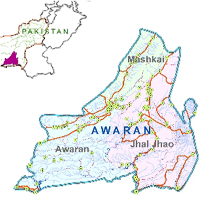
Awaran’s history is marked by its strategic location and its role as a junction for historical trade and military routes. The district’s transformation from a historical area to an administrative unit reflects its evolving significance in the broader context of Balochistan and Pakistan.
Ancient and Pre-Partition Era
- Early History: The early history of Awaran and its surrounding region is relatively obscure. Limited historical records exist prior to the 7th century AD, when Arab forces displaced the Rai Dynasty of Sindh.
- Greek Influence: General Krateros of Alexander’s army is mentioned in historical texts for crossing into Persia via the Mula Pass, potentially passing through the area that includes modern Khuzdar. This is the earliest recorded reference to the region in historical documents.
Medieval and Islamic Era
- Arab Rule: During the Arab rule, Khuzdar, the principal settlement in the region, was strategically significant. It was located at the convergence of major trade and military routes from Multan (via Mula Pass), Makran, and Kandahar. Awaran was on the route used by Arab trading caravans and military expeditions.
British Era
- British Administration: Under British rule, Khuzdar served as the headquarters of the Jhalawan Division of the Kalat State. This administrative structure was part of the larger Balochistan region managed by the British.
Post-Independence Era
- Partition and One Unit: At the time of Pakistan’s independence in 1947, Jhalawan was part of the southernmost district/subdivision of the Balochistan State Union, which included Kalat, Kharan, Makran, and Lasbela. In 1955, with the formation of the “One Unit” system, all princely states were abolished, and the region was integrated into West Pakistan.
Formation of Awaran District
- Creation as a District: Awaran was officially established as a separate district on 11 November 1992, after previously functioning as a tehsil of Khuzdar District. The old name of Awaran was Kolwa, derived from Kolwa Chil, a local stream. The name “Awaran” is believed to come from “Awar,” meaning a union of streams, reflecting the geographical confluence of Kolwa Chil and Doraski stream among others.
Contemporary Significance
- Strategic Location: Awaran is situated at the confluence of important trade and transport routes, including the link road between Turbat-Gwadar-Karachi and the Karachi-Quetta RCD highway. This strategic location continues to influence its connectivity and significance in the region
Awaran’s ecological landscape, while sparse in some areas, is enriched by the protected zones and unique species of Hingol National Park, highlighting the district’s role in regional biodiversity conservation.
Flora
General Vegetation: Awaran district has limited vegetation, with few trees and scanty forest cover. The predominant tree in the region is the date palm.
Common Flora:
- Khagal (Tamarix spp.): Known for its ability to thrive in arid conditions.
- Willow (Salix spp.): Often found near water sources.
- Chitta Kanda (Otostegia auohesi): A plant adapted to dry environments.
- Caper Bush (Pyonotheco spinosa): A spiny shrub.
- Jujube (Zizyphus nummularia): Known locally as ber, this tree produces edible fruit.
- Kikar (Acacia jaquemontii): Common in arid regions.
- Vann or Jal/Pilu (Salvadora oleoides): A hardy bush.
- Gugal or Mukul Myrrh (Commiphora mukal): Used for its aromatic resin.
- Mazari Palm (Nannorrhops ritchieana): Adapted to dry climates.
- Khijri (Prosopis cineraria): Also known as the long tree.
- Arabic Gum (Acacia nilotica): Produces gum used in various applications.
Flora in Hingol National Park:
- Babul or Kikar (Acacia nilotica): Found in arid regions.
- Gum Arabic or Khumbat (Acacia Senegal): Produces gum used in food and industrial applications.
- Aak (Calotropis procera): A plant known for its medicinal properties.
- Appi Api Putih (Avicennia alba): A mangrove species.
- Karir (Capparis decidua): An edible and medicinal plant.
- Khavi Grass (Cymbopogon jwarancusa): Used for its essential oils.
- Valaiti Babul (Parkinsonia aculeata): Also known as the Jerusalem thorn.
- Sirin (Cassia italica): Known for its ornamental and medicinal uses.
Fauna
Protected Areas and Wildlife
Hingol National Park: Covers parts of Awaran and is a critical habitat for various species. It provides protection to species like the Sindh ibex, chinkara gazelle, Afghan urial, black bear, marsh crocodile, and houbara bustard.
Kolwakop Wildlife Sanctuary: Another protected area in the district, contributing to the conservation of local wildlife and their habitats.
Agro-Ecological Zone
Awaran district falls within the Dry Western Plateau Agro-Ecological Zone of Pakistan. Farming in the district is primarily barani (rain-fed), with many areas dependent on seasonal rainfall. Irrigation is achieved through traditional methods such as springs, karezes (ancient underground channels), and tube wells.
Crops
Fruits
- Common Fruits:
- Apples: Grown in cooler, higher-altitude areas.
- Apricots: Cultivated for their edible fruit.
- Peach and Plums: Popular stone fruits.
- Grapes and Pomegranates: Widely grown fruits.
- Almonds and Dates: Nutritious and economically important.
- Watermelon and Musk Melon: Summer fruits appreciated for their refreshing qualities.
Vegetables
- Common Vegetables:
- Onions and Potatoes: Staple vegetables for local diets.
- Chilies and Tomatoes: Essential for local cuisine.
- Coriander and Peas: Used for flavor and nutrition.
- Okra, Tinda (Apple Gourd), Radish, and Spinach: Diverse vegetable crops.
- Cabbage, Carrots, Bitter Gourd, Bottle Gourd, Brinjal (Eggplant), Luffa (Ridge Gourd), and Cucumber: Various other vegetables suited to the local climate.
The agricultural practices in Awaran are adapted to the district’s challenging environment, making use of available water resources and focusing on crops that can withstand the region’s arid conditions.
Handicrafts; Awaran district
The only handicrafts of the district are embroidery on clothes, and sandals/shoe making, which is generally undertaken by the women of the district, who sell their work (completed in the domestic setting) to brokers at low prices. This work is subsequently sold in urban markets like Karachi and Quetta.


